Schmidt Ocean Institute "EYES BELOW THE SURFACE"
In the last few years, various U.S. Marine National Monuments located in the Pacific have been expanded to approximately four times the previous area, enclosing a great number of additional seafloor features.
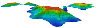
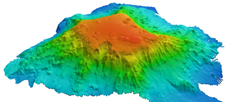
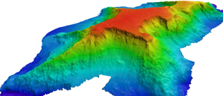
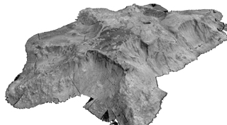
The Johnston Atoll Unit (JAU), of the Pacific Remote Islands Marine National Monument, was an area of particular interest on the RV Falkor’s latest “Transruise” called Eyes Below the Surface: Mapping Johnston Atoll (use this link: https://schmidtocean.org/cruise/eyes-testing-uavs-mapping-johnston-atoll/). The RV Falkor was scheduled to relocate to Honolulu, and for the first time, took a science team on board for the transit. The ship made a short detour to conduct a survey within the recently expanded JAU. Chief Scientist, John Smith, of the University of Hawaii, elected to survey seamounts outside of the original 100nm boundary, within the current 200nm boundary. It will take some time to generate a full analysis, but the seamounts that were uncovered were both unusual and complex.
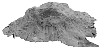
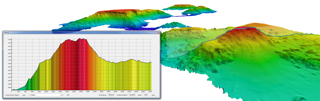
The science team, from the University of Hawaii, used Qimera to edit the bathymetry data and Fledermaus to view and manipulate the digital terrains. Seafloor backscatter is of particular interest because one of the primary goals of this survey is to identify potential deep sea coral habitats, which also harbor sponges and other critters in dense communities. The cleaned bathymetry was exported from Qimera as GSF, and simply imported into FMGT. The mosaic generated from the cleaned files were then draped over the bathymetry in Fledermaus. This is the first cruise in which all of the bathymetry data was processed in Qimera onboard RV Falkor. The transition between these three products was simple and efficient. The non-science members of the mapping team were able to learn how to edit the bathymetry data very easily. The science team looks forward to using Qimera for future missions
Credit: Schmidt Ocean Institute, University of Hawaii and QPS